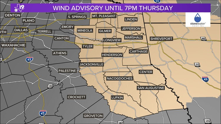
TYLER, Texas — The main part of the storm that came through the first half of this week with what seemed like endless rain and a severe weather threat is starting to move away from East Texas. In the wake of this storm are gusty winds that have prompted a wind advisory until Thursday evening.
Across East Texas, wind gusts up to 35 mph could topple trees because of the soggy ground.
Follow our live blog for the latest information.
Wednesday, April 10
6:20PM- The National Weather Service has issued a flood watch until 7 a.m. Thursday for the following counties:
- Franklin
- Harrison
- Wood
- Upshur
- Cass
- Smith
- Gregg
- Marion
- Morris
- Camp
- Titus
The National Weather Service has a wind advisory for the following counties until 7 p.m. Thursday:
- Cherokee
- Wood
- Rusk
- Sabine
- Cass
- Smith
- Marion
- Morris
- Titus
- Franklin
- Harrison
- Upshur
- Gregg
- Nacogdoches
- Shelby
- Angelina
- Camp
- San Augustine
- Panola
Tuesday, April 9
11:42PM - The National Weather Service has issued a Severe Thunderstorm Warning for the following counties until 12:45 a.m. Wednesday:
- Angelina County
10:40PM - The National Weather Service has issued a Tornado Watch for the following counties until 1 a.m. Wednesday:
- Sabine County
- San Augustine County
8:50PM - The National Weather Service has issued a Tornado Warning until 9:15 p.m. for the following counties:
- Sabine County
8:10PM - The National Weather Service has issued a Severe Thunderstorm Warning until 9 p.m. for the following counties:
- Sabine County
- Shelby County
- San Augustine County
4:50PM - The National Weather Service has CANCELED the Tornado Watch for the following counties:
- Cherokee County
- Harrison County
- Rusk County
- Smith County
- Gregg County
- Nacogdoches County
- Shelby County
- Panola County
4:27PM - The National Weather Service has issued a Tornado Watch for the following counties until 5 p.m.:
- Anderson County
- Henderson County
3:52PM - The National Weather Service has issued a Severe Thunderstorm Warning until 4:30 p.m. for the following counties:
- Harrison County
- Shelby County
- Panola County
3:44PM - The National Weather Service has issued a Flash Flood Warning until 6:30 p.m. for the following counties:
- Cherokee
- Rusk
- Gregg
- Smith
- Nacogdoches
- Shelby
- Panola
The National Weather Service has issued a Flash Flood Warning until 6:45 p.m. for the following counties:
- Harrison
- Panola
3:16PM - The National Weather Service has issued a Severe Thunderstorm Warning until 4 p.m. for the following counties:
- Rusk
- Nacogdoches
- Shelby
- Panola
2:40PM - The National Weather Service has issued a Severe Thunderstorm Warning until 3:30 p.m. for the following counties:
- Cherokee County
- Rusk County
- Nacogdoches County
- Shelby County
- Panola County
2:25PM - The National Weather Service has issued a Tornado Watch until 9 p.m. for the following counties:
- Cherokee County
- Harrison County
- Rusk County
- Sabine County
- Smith County
- Gregg County
- Nacogdoches County
- Shelby County
- Angelina County
- San Augustine County
- Panola County
11AM - The National Weather Service has issued a Tornado Warning until 11:45 a.m. for the following counties:
- Henderson County
- Van Zandt County
Officials say a severe thunderstorm capable of producing a tornado was located near Athens, moving east at 40MPH. Flying debris will be dangerous to those caught without shelter. Mobile homes could be damaged or destroyed.
TAKE COVER NOW! Move to an interior room on the lowest floor of a sturdy building. Avoid windows. If you are outdoors, in a mobile home, or in a vehicle, move to the closest substantial shelter and protect yourself from flying debris.
The National Weather Service says this storm will be near Brownsboro at 11:05 a.m., near Edom around 11:15 a.m., and will move into the Chandler/Lake Palestine area around 11:20 a.m.

10AM - The National Weather Service has issued a Tornado Watch until 5 p.m. for the following counties:
- Anderson County
- Henderson County
- Houston County
6:30AM - The National Weather Service has extended a Flash Flood Warning until 10:30 a.m. for the following counties:
- Cass County
- Cherokee County
- Gregg County
- Harrison County
- Marion County
- Panola County
- Rusk County
- Smith County
Monday, April 8
10:20PM - The National Weather Service has canceled a Tornado Watch for the following counties:
- Henderson County
- Anderson County
7:50PM - The National Weather Service has issued a Tornado Watch for the following counties until 1 a.m.:
- Anderson County
- Cherokee County
- Gregg County
- Harrison County
- Henderson County
- Marion County
- Nacogdoches County
- Panola County
- Rusk County
- Shelby County
- Smith County
- Upshur County
5:30PM - The National Weather Service has issued a Severe Thunderstorm Warning for the following counties until 6:00 p.m.
- Cherokee County
- Smith County
5PM - The National Weather Service has issued a Severe Thunderstorm Warning for the following counties until 5:45 p.m.
- Anderson County
5PM - The National Weather Service has issued a Severe Thunderstorm Warning for the following counties until 5:30 p.m.
- Cherokee County
4:20PM - The National Weather Service has canceled a Tornado Watch for the following counties:
- Trinity County
2:40PM - The National Weather Service has issued a Severe Thunderstorm Warning for the following counties until 3:45 p.m.:
- Nacogdoches County
- Angelina County
- San Augustine County
1:30PM - The National Weather Service has issued a Tornado Watch for the following counties until 8 p.m.:
- Anderson County
- Angelina County
- Cherokee County
- Houston County
- Nacogdoches County
- Panola County
- Polk County
- Rusk County
- Sabine County
- San Augustine County
- Shelby County
- Trinity County
10:20AM - The National Weather Service has extended a Flood Warning for Smith County and Wood County "until further notice."
7:45AM - Currently, all of East Texas is under either a marginal (Level 1 of 5) or slight (Level 2 of 5) risk for severe weather from 7 a.m. on Wednesday through 7 a.m. Thursday.
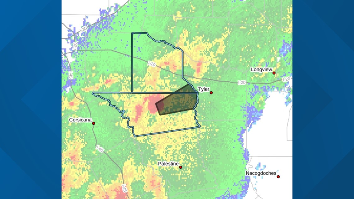
"Damaging winds, tornadoes and large hail are possible," the National Weather Service said. "Excessive heavy rainfall is likely, which will result in a threat of flooding (see graphic below)."
7:30AM - According to the CBS19 Weather Experts, soon after the eclipse, thunderstorms will work their way into East Texas. The Storm Prediction Center has all of East Texas under at least a slight risk (Level 2 of 5) for strong storms, so that means heavy rain, gusty winds and large hail are all possible. Portions of Deep East Texas are under an enhanced risk (Level 3 of 5) for severe weather which comes with higher threat of damaging winds and tornadoes, per the National Weather Service (see graphic below).
Sunday, April 7
8:15PM - The National Weather Service has issued a Flood Watch for the following counties from Monday, April 8, at 12 p.m. through Wednesday, April 10, at 7 p.m.:
- Angelina County
- Camp County
- Cass County
- Cherokee County
- Franklin County
- Gregg County
- Harrison County
- Marion County
- Nacogdoches County
- Panola County
- Rusk County
- Sabine County
- San Augustine County
- Shelby County
- Smith County
- Titus County
- Upshur County
- Wood County