
TYLER, Texas — Winter Weather Advisory:
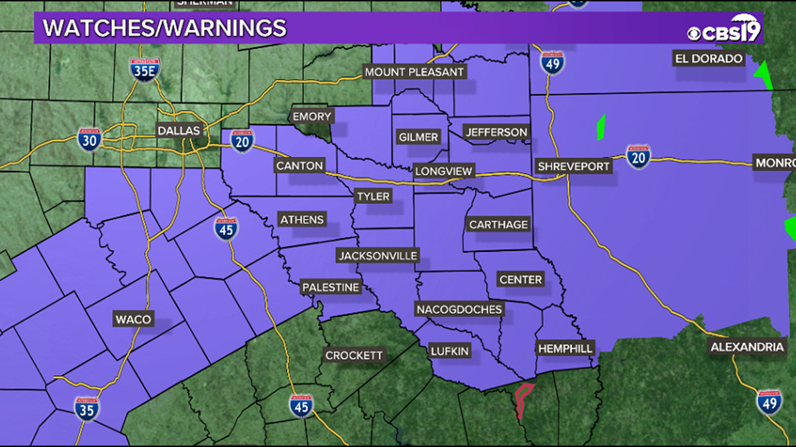
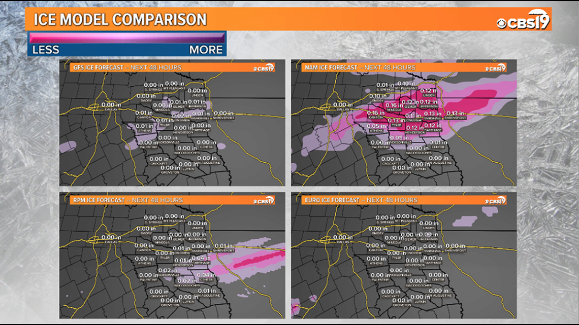
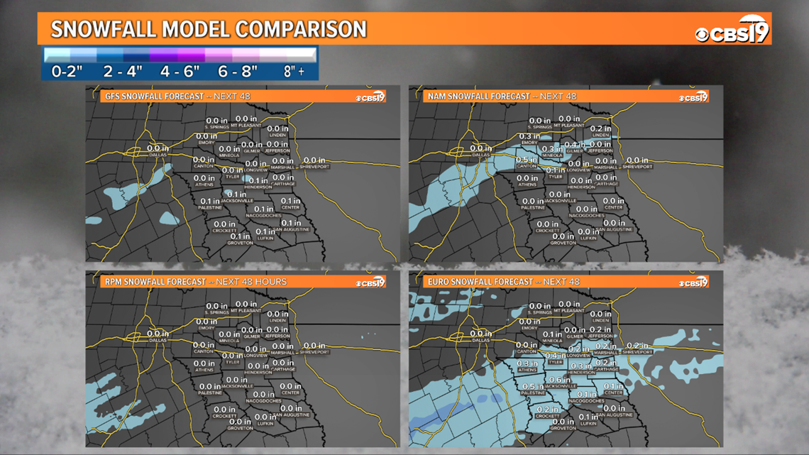
A Winter Weather Advisory has been issued for Henderson, and Anderson Counties until 3 am tonight. A second Winter Weather Advisory has been issued for Angelina, Camp, Cass, Cherokee, Franklin, Gregg, Harrison, Marion, Morris, Nacogdoches, Panola, Rusk, Sabine, San Augustine, Shelby, Smith, Titus, Upshur, and Wood Counties until 9 am. The main concern will be for light accumulating snow and accumulating sleet/ice. Bridges and overpasses will be of main concern. Such areas could see up to a 1/2 inch of snow and sleet, along with ice accumulations expected to be under 1/10 of an inch. Please use caution during the evening commute and through tonight and early Saturday.
Forecast:
As of 9:30 PM, most of the precipitation that has fallen across East Texas has been in the from of sleet, or a very cold rain. Temperatures are not expected to change much throughout the night so we are not expecting a big change or switch over to all snow. Although we have not seen much snow, we are still expecting there to be some isolated slick spots overnight and into Saturday morning.


Tonight:
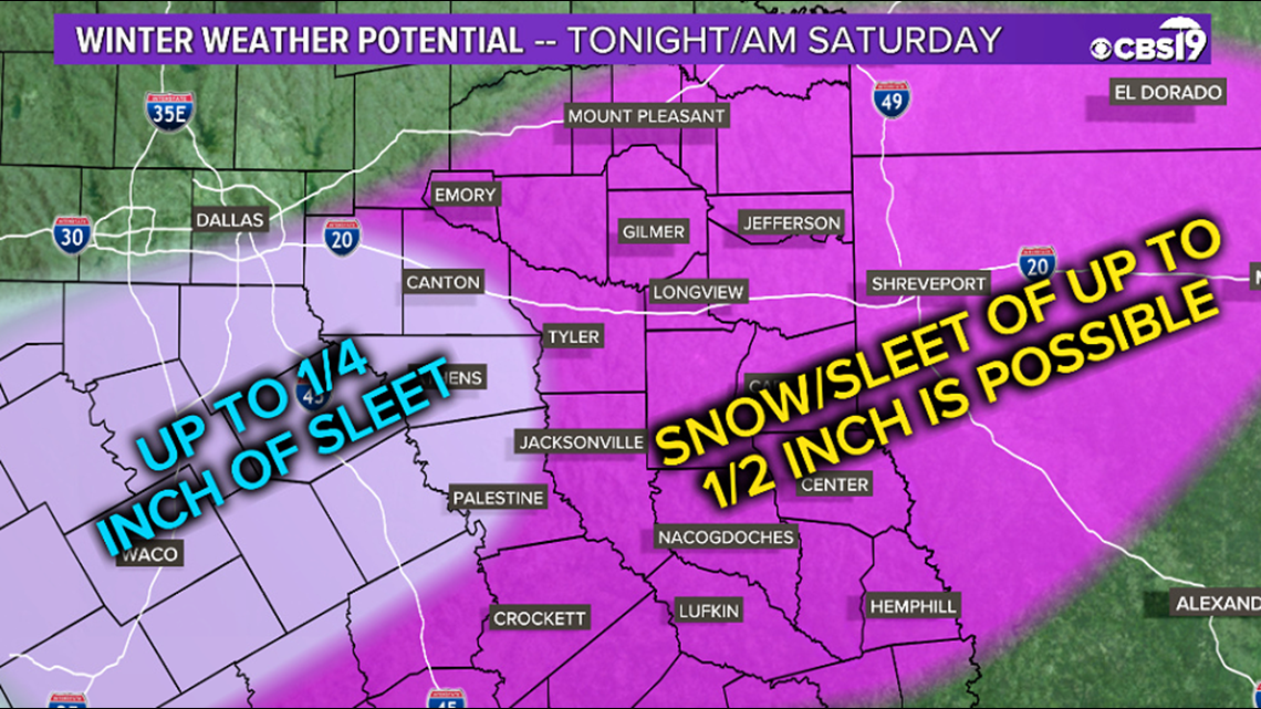
There is the potential for travel impacts all across East Texas tonight. Our western counties could see up to 1/4 inch of sleet in some locations, mainly on elevated roads and bridges. Elevated roads and bridges in the heart of East Texas, Deep East Texas, and north toward the Arklatex could see accumulations of sleet and snow up to 1/2 inch along with some minimal ice accumulations. Accumulations on non-elevated surfaces should be less, but are also possible. Do expect some slick spots, especially on bridges and elevated roads, and allow extra time and use caution during your evening commute.
Tonight will see continued chances for a rain/snow/sleet mix across East Texas. This chance will not be limited to one spot around East Texas, and everyone should be ready for at least the potential of slick roads. Travel impacts are possible around the region, but will mostly be limited to bridges and elevated roads. Accumulations could reach as high as 1/2 of an inch of sleet/snow, but most locations should see less than this. Expect a low tonight around 32, and any accumulations to melt off during the day on Saturday.
Connect with CBS 19 Chief Meteorologist Joel Barnes on social media:


Do you have a weather report or pictures you would like to submit to the CBS19 Weather team? You can email news@cbs19.tv and visit our Facebook or Twitter pages.