
TYLER, Texas — Good evening East Texas,
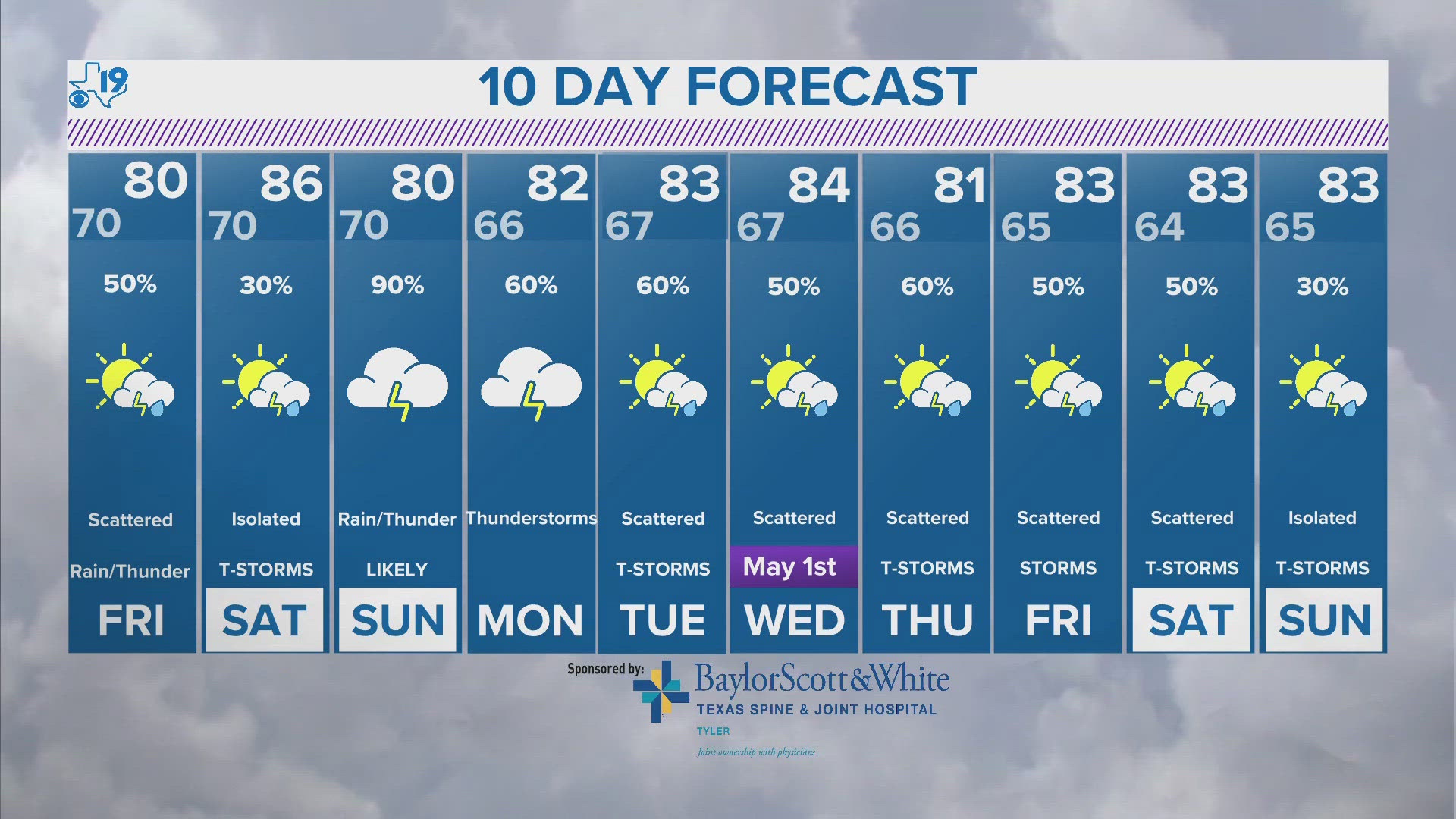
One thing is sure as we head into the end of the week. An active weather pattern is emerging across the central and southern plains. Pinpointing where, when and if you see severe weather is a different matter. At this time, despite the slight risk for severe weather, East Texas may end up with a mostly dry day Friday. The best energy for severe weather will be over North Texas and extend into Oklahoma and Arkansas. Still worth keeping an eye on but for now there will not be an Eye on Weather Day Friday. Sunday could be a different story. At this time, Sunday also has a level 2 risk out of 5 for severe weather.
Here's your forecast:
TONIGHT:
It feels like a rinse and repeat forecast. Once again tonight, we will see plenty of clouds and humidity and warm temperatures. We could also experience some patchy fog and mist. Tonight's overnight low will fall into the low-70s.
TOMORROW:
Friday will feel very much like the last couple of days. It will be breezy, warm and humid with breaks in the overcast. Just after sunrise, keep an eye on thunderstorms that move along and north of Interstate 20. These thunderstorms could pack a punch with some gusty winds and large hail. Once this wave moves into Oklahoma, most of us will see an extended break from thunderstorms that could last into Sunday. The only exception will be the isolated thunderstorms that will be possible across East Texas. Any thunderstorm that develops could provide plenty of thunder and lightning but at this point, the main severe weather appears to be Friday morning northwest of Tyler.
THIS WEEKEND:
Saturday will be the nicest day of the weekend. We'll see a partly cloudy sky and a high in the mid-80s. It will, however, be a windy and warm day and that could help set the table for severe weather on Sunday. Sunday, we've got another energetic wave racing through and near East Texas. Thunderstorms are expected to develop Sunday afternoon and continue through the evening and overnight into Monday. In addition to the wind, tornado and hail threat, there will be heightened concern for flash flooding. The Weather Prediction Center already has East Texas under a Slight Risk for Flash Flooding for Sunday and Sunday night.
Get the latest on the forecast from Brett Anthony on social media by following:
Do you have a weather report or pictures you would like to submit to the CBS19 Weather team? You can email news@cbs19.tv and visit our Facebook or Twitter pages.
Keep up with the latest news, weather and sports by downloading the FREE CBS19 mobile app:
- Click here to download the iPhone app
- Click here to download the iPad app
- Click here to download the Android app
Make it a great day, East Texas. And don't worry, we're putting you first!