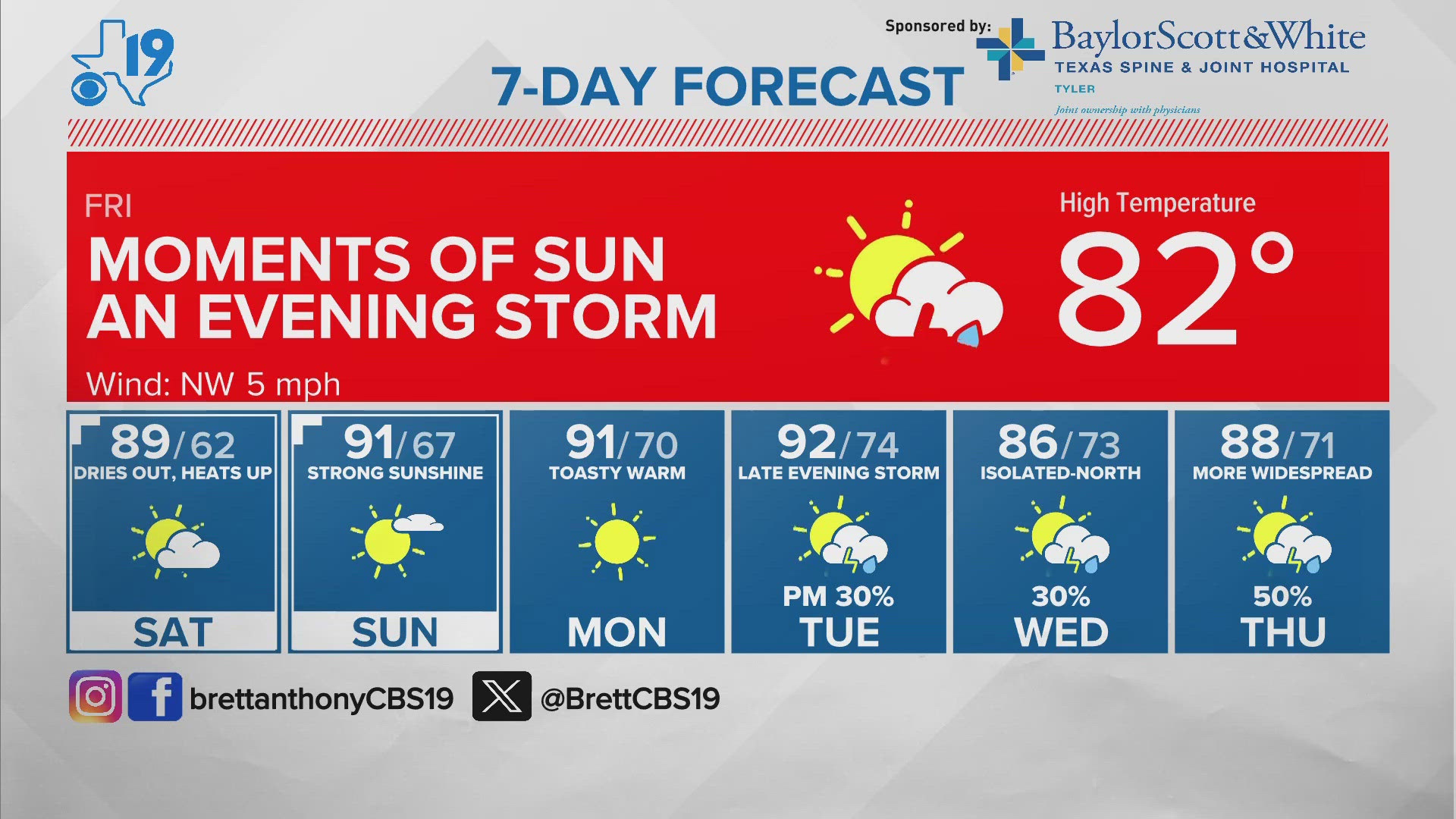
TYLER, Texas — East Texas has seen some stellar sunsets this week and we can look for many more as we roll into next week.
Why? Well this week, several wildfires over West and Central Texas are filling the skies with smoke at high altitudes.


The smoke enhances the red and orange colors at sunset. That's because of the wavelength of different colors on the visible light spectrum. Since red has a longer wavelength and the sun is lower in the sky at sunset, the red or orange color dominates the sky.
And, heads up, East Texas! Late this weekend Saharan Dust arrives and like the May heat, the dust plume is at least a month, if not two, early.
That might have a bit of a doom and gloom sound, but don't worry, it happens about every year -- usually in July, but this year, the Saharan Dust layer, like the heat, is ahead of schedule.
What is the Saharan Dust layer or SAL? It's a dust cloud that forms every year thanks to thunderstorms in the African Saheel region. That region borders the Sahara desert. The trade winds that blow east to west over the Atlantic Ocean send plumes of dust across the Atlantic and into the Gulf of Mexico.
We track it here in the CBS19 Weather Center. Satellites pick it up when the dust layer is thick and this year it's thick enough to track. We're better at it now because of advanced satellites that can tell how much power is lost as sunlight passes through the atmosphere.
The fancy name is Aerosol Optical Thickness or AOT. But all that jargon aside, here's the birds-eye view of what that looks like from space.

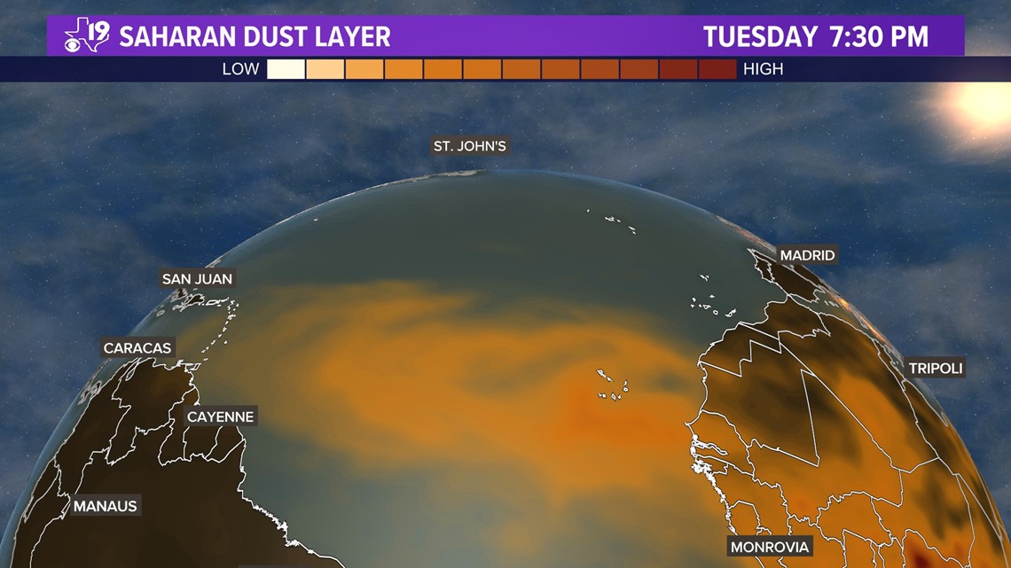
The SAL is the tan shaded area between the west coast of Africa (Monrovia) and the Leeward islands (San Juan, Puerto Rico). The layer or air driving the dust plume across the Atlantic is about a mile above the surface. It stays there due in part to strong winds, very dry air and very warm temperatures.
These elevated dust clouds can suppress tropical storm and hurricane development in the Atlantic and Gulf of Mexico. Using the same AOT data, we can forecast where the Saharan Air Layer is headed. This particular forecast pushes the dust plume into the Gulf of Mexico and into parts of East Texas by Sunday.
Here's a forecast animation of the Saharan Dust through Sunday.
What we will likely notice here in East Texas will be colorful sunsets this weekend and early next week. If you are sensitive to air quality you may notice some added difficulty in breathing and some of us will have allergy symptoms at a time of the year when we usually don't experience any.
Some dust may already be in our atmosphere and that might explain why allergy numbers have been a little higher than usual this week. That happens because Saharan dust is not the usual kind of dust we find in the Piney Woods region.
The dust doesn't pose any serious threat but it could do something else. We are forecasting rain and thunderstorms during the middle of next week.
Sometimes, Saharan Dust can suppress thunderstorm development causing the sky to remain hazy for days and can lead to hotter days. The area will warm up in the second half of next week and Saharan Dust may play a role.


Another thing we may notice is some dirty rain. If it does rain next week, your car may be dirtier than before it rained. That's because the rainfall has all those dust particulates and some of that will settle on your car. Since this is an early season Saharan Air Layer episode, another plume could be expected during late June or July when it typically happens.