
TYLER, Texas — A chance for severe weather is possible this weekend across East Texas.
The spring severe weather outlook issued in early March cautioned of increased severe weather setups by the end of April, lasting into early May. And right on schedule, severe weather season is starting to finally show up in East Texas.
Follow our live blog for the latest information.
SUNDAY, APRIL 28
11:18PM - Trinity County Sheriff Woody Wallace reported a possible tornado touched down at 10700 block of FM 2262, where a house no longer has a roof.
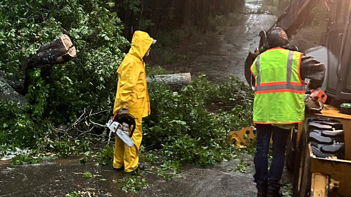
FM 356 is shut down from Westwood to Trinity due to water on the roadway. Highway 94 at steel horse is flooded over as well as Highway 94 at Boontown. FM 1280 is flooded and not passable onto US Highway 287.
US 287 in Woodlake is flooded and not passable. FM 233 is not passable in multiple places in a car.
10:53PM - The National Weather Service has extended a TORNADO WATCH for the following counties until 1 a.m. Monday:
- Sabine
- Nacogdoches
- Shelby
- Angelina
- San Augustine
10:45PM - The National Weather Service has issued TORNADO WARNING for the following counties until 11:15 p.m.:
- Nacogdoches
- Angelina
- San Augustine
10:15PM - The National Weather Service has issued TORNADO WARNING for the following counties until 10:45 p.m.:
- Angelina
9 PM - The National Weather Service has extended a TORNADO WATCH for the following counties until 11 p.m.:
- Houston
- Trinity
8:45 PM - The National Weather Service has extended a TORNADO WATCH for the following counties until 11 p.m.:
- Cherokee
- Harrison
- Rusk
- Sabine
- Smith
- Gregg
- Nacogdoches
- Shelby
- Angelina
- San Augustine
- Panola
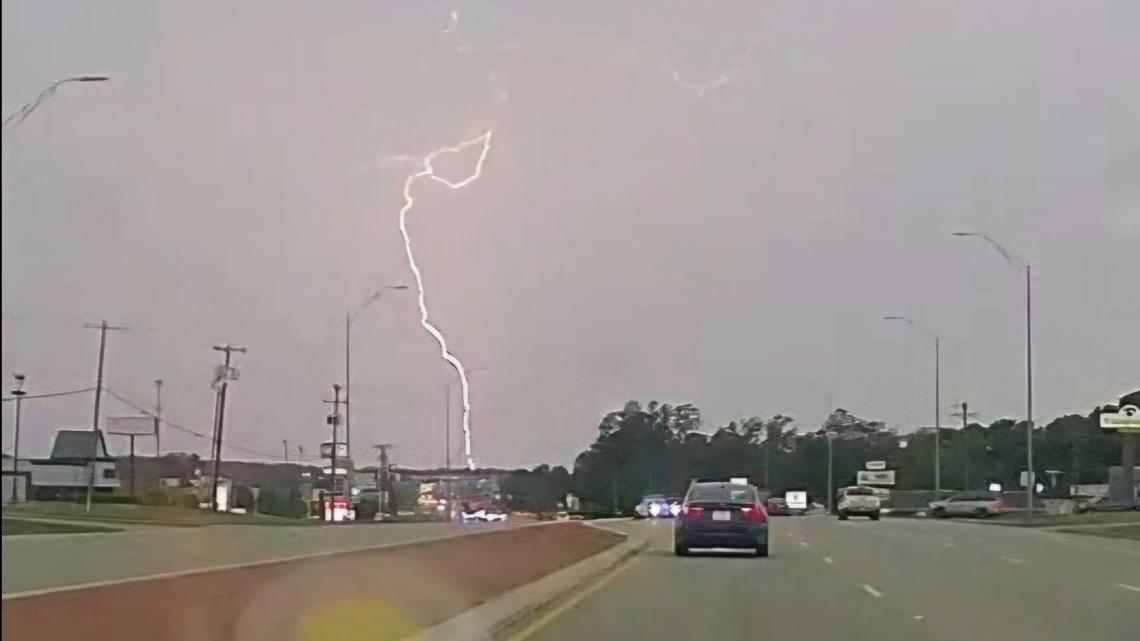
8:30 PM - Cherokee County Sheriff Brent Dickson said a storm chaser called in to say they spotted a possible tornado on Highway 21 east of Alto. Dickson believes it was possibly near the Cherokee and Nacogdoches County lines.
He said there have been no reports of injuries. The sheriff's office has heard that trees down in the roadways across the county, including between Jacksonville and Rusk on US Highway 69. Trees are also down in the areas of FM 22, US Highway 84 and Highway 110.
8:20PM - Thanks to Pam Crump, of Gilmer, for this spectacular picture of the sunset after the storm.


8:13PM - Thanks to Jarrell Truitt, of Kilgore, for this beautiful post-storm photo.


7:56PM - Trees have been reported down off FM 1514 in Cherokee County.


7:54PM - Thanks to Bethany Moore for this beautiful shot of a rainbow following severe storms in East Texas!


7:41PM - The National Weather Service has issued a TORNADO WARNING for Nacogdoches and Rusk counties until 8:15 p.m.
7:17PM - The National Weather Service has issued a TORNADO WARNING for Cherokee, Houston and Nacogdoches counties until 7:45 p.m.
6:59PM - The National Weather Service has issued a TORNADO WARNING for Cherokee County until 7:30 p.m.
6:18PM - Trees have been reported down on FM 22, Hwy. 69, Hwy. 84, Hwy. 110 and Hwy. 204 in Cherokee County .
6:15PM - The National Weather Service has issued a TORNADO WARNING for Houston County until 7 p.m.
5:27PM - The National Weather Service has issued a TORNADO WARNING for Houston County until 6:15 p.m.
5PM - The National Weather Service has issued a TORNADO WARNING for Anderson County until 5:30 p.m.
4PM - The National Weather Service has issued a TORNADO WARNING for Anderson County until 5 p.m.
2:30PM - The National Weather Service has issued a TORNADO WATCH for the following counties until 9 p.m:
- Anderson
- Angelina
- Cherokee
- Gregg
- Harrison
- Henderson
- Houston
- Nacogdoches
- Panola
- Rusk
- Sabine
- San Augustine
- Shelby
- Smith
- Trinity
A couple of tornadoes are possible, as well as 2" hail and scattered wind gusts up to 70 MPH.


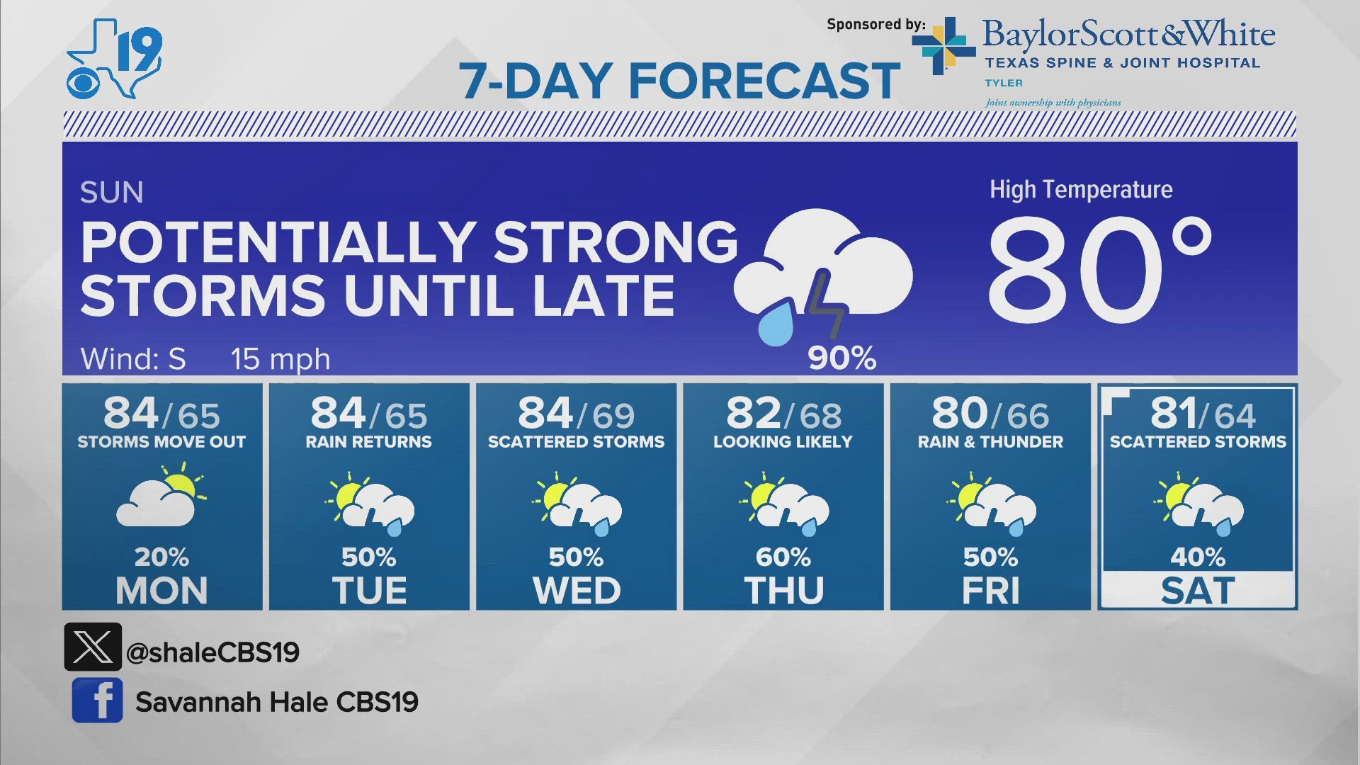
8:40AM - The CBS19 Weather Experts have identified Sunday as a CBS19 Eye on Weather Day due to another energetic wave racing through East Texas.
Thunderstorms are expected to develop Sunday afternoon and continue through the evening and overnight. In addition to the wind, tornado and hail threat, there will be heightened concern for flash flooding.
The Weather Prediction Center already has East Texas under a Slight Risk for Flash Flooding for Sunday, as well as a slight risk for strong to severe storms.
Sunday night's storms look to be relatively strong. After popping up and moving to the northeast, late on Sunday they will begin to slow before moving back to the southeast. However, by the time you wake up and leave for work Monday morning, the storms will most likely be out of the area and leave behind a partly cloudy day.
FRIDAY, APRIL 26
8:40PM - The National Weather Service has issued a SEVERE THUNDERSTORM WARNING for the following counties till 9:30 p.m.
- Morris County
- Titus County
8:37PM - The National Weather Service has cancelled the TORNADO WATCH for the following counties
- Wood County
- Smith County
8PM - The National Weather Service has issued a TORNADO WATCH for the following counties till 11:00 p.m.
- Henderson County
- Anderson County
- Van Zandt County
- Rains County
- Hopkins County
7:56PM - The National Weather Service has issued a SEVERE THUNDERSTORM WARNING for the following counties till 8:45 p.m.
- Franklin County
- Wood County
- Morris County
- Camp County
- Titus County
7:42PM - The National Weather Service has issued a SEVERE THUNDERSTORM WARNING for the following counties till 8:30 p.m.
- Cass County
- Morris County
- Camp County
- Titus County
7:08 PM - The National Weather Service has issued a SEVERE THUNDERSTORM WARNING for the following counties till 8:00 p.m.
- Wood County
- Upshur County
7PM - The National Weather Service has issued a SEVERE THUNDERSTORM WARNING for the following counties till 7:45 p.m.
- Franklin
- Wood
- Upshur
- Morris
- Camp
- Titus
6PM - The National Weather Service has issued a SEVERE THUNDERSTORM WARNING for the following counties till 7 p.m.
- Franklin
- Wood
- Upshur
- Smith
- Camp
6:05PM - The National Weather Service has issued a TORNADO WARNING for the following counties till 6:30 p.m.
- Van Zandt County
- Rains County
6PM - The National Weather Service has issued a TORNADO WATCH for the following counties till 11 p.m.
- Franklin County
- Harrison County
- Wood County
- Upshur County
- Cass County
- Smith County
- Gregg County
- Marion County
- Morris County
- Camp County
- Titus County
5:50PM - The National Weather Service has issued a TORNADO WARNING for the following counties till 6:15 p.m.
- Cass County
- Morris County
5:40PM - The National Weather Service has issued a SEVERE THUNDERSTORM WARNING for the following counties till 6:45 p.m.
- Cass County
- Morris County
- Camp County
- Titus County
5:04PM - The National Weather Service has issued a SEVERE THUNDERSTORM WARNING for the following counties till 6:00 p.m.
- Franklin County
- Wood County
- Upshur County
- Smith County
- Morris County
- Camp County
- Titus County
4:50PM - The National Weather Service has issued a TORNADO WARNING for the following counties till 5:15 p.m.
- Van Zandt County
4:38PM - The National Weather Service has issued a SEVERE THUNDERSTORM WARNING for the following counties till 5:30 p.m.
- Franklin County
- Wood County
- Hopkins County
4:30PM - The National Weather Service has issued a SEVERE THUNDERSTORM WARNING for the following counties till 5:30 p.m.
- Henderson County
- Van Zandt County
- Rains County
4:20 PM - The National Weather Service has issued a TORNADO WARNING for the following counties till 5:00 p.m.
- Van Zandt County
3:50PM - The National Weather Service has issued a SEVERE THUNDERSTORM WARNING for the following counties till 4:30 p.m.
- Henderson County
- Van Zandt County
- Rains County
2:30PM - The National Weather Service has issued a TORNADO WARNING for the following counties till 3:15 p.m.
- Henderson County
2:25PM - The National Weather Service has issued a FLOOD WATCH for the following counties till 1:00 p.m. on April 28
- Henderson County
- Van Zandt County
- Rains County
- Hopkins County
10:15AM - The National Weather Service has issued a TORNADO WATCH for the following East Texas counties until 6 p.m.:
- Anderson
- Camp
- Cass
- Cherokee
- Franklin
- Gregg
- Harrison
- Henderson
- Hopkins
- Marion
- Morris
- Panola
- Rains
- Rusk
- Smith
- Titus
- Upshur
- Van Zandt
- Wood
The NWS says a few tornadoes are possible, along with scattered hail up to tennis ball-size and wind gusts of up to 70MPH.