TYLER, Texas — The Arctic plunge continues for East Texas. This morning, Tyler and Longview set all-time low temperature records. The temperature in Tyler fell to six below zero. In Longview, the thermometer bottomed out at five below zero. We are frozen and it’s about to get worse for some in East Texas.
A second Winter Storm Warning for our area is now in effect until midday Thursday. Here’s a statement from the National Weather Office in Fort Worth in advance of the storm moving into the Lone Star State.
“Another winter storm will arrive tonight bringing another round of ice and snow to the region. Significant ice accumulation is possible over Central Texas and our southeast counties with significant snowfall possible over North and Northeast Texas. This will fall on to already existing snow/ice and only worsen existing impacts. This system should move east of the area on Wednesday with above freezing temperatures finally returning Friday and/or Saturday afternoon. However, significant melting would likely not occur until Saturday. Temperatures and wind chills will be “slightly warmer” the next few days but still considered dangerously cold throughout least Friday afternoon.”
As of Tuesday evening the storm was just moving into West Texas. Here’s a look at the evening clouds/rain and snow map that shows a large area of snow moving toward East Texas.

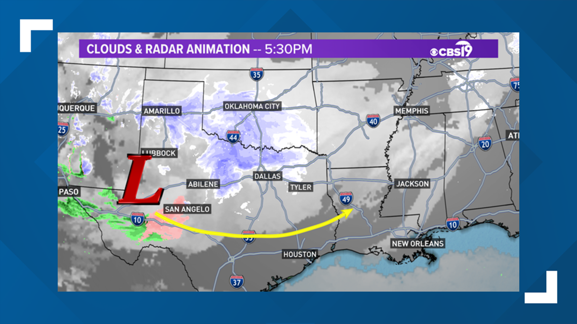
See the yellow arrow? Our next storm will follow this flow as it digs deeper into Texas and ejects into the Ark-La-Miss by Thursday afternoon. Do you remember the end of December?
We had more than five inches of rain with a series of systems that passed through the middle of the country. This is part of the cycling weather pattern and we knew this period of time would bring significant weather to East Texas.
Of course, the wild card this time is the Arctic air that came along with these systems. Look for this part of the pattern to repeat in roughly six weeks. It will be early April. It won’t be snow but rather a severe weather threat, We will be watching this time frame carefully. But let’s get back to this week’s storm.
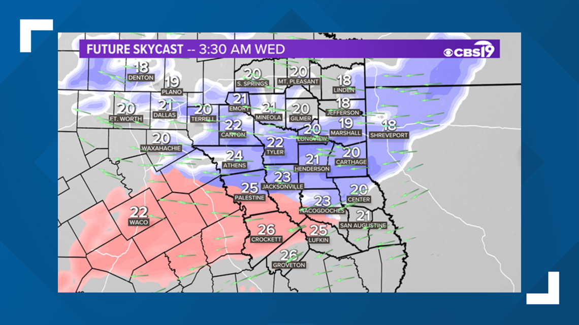
Once the storm reaches East Texas tonight, warmer and more humid air from both the Gulf of Mexico and Pacific Ocean will begin streaming into Texas, riding over top a shallow layer of subfreezing air near the surface, You will see on the map areas in pink and blue. The pink shaded areas represent precipitation that should be a mix of freezing rain, sleet and snow.

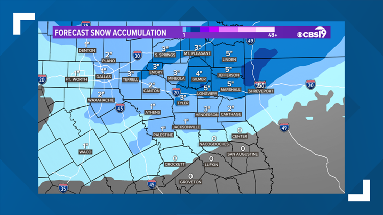
This time around the heaviest snow should target North Texas. Take a look at the snowfall outlook for this storm. But really keep in mind the numbers you are seeing will shift north and south, so think of this as more of a possible range.


Deep East Texas will be in a prime spot for sleet and freezing rain. How much sleet? How much freezing rain? The atmosphere has many slabs of air and the temperature of each layer will be highly dependent on whether snow, sleet or freezing rain falls.
This particular piece of computer data is sampling some warmer air over top of a colder surface. When we look at forecasts that show us the layers of the atmosphere, there is something very concerning. At about 10,000 feet above the earth, the temperature is below freezing.
So the precipitation likely begins as snow, but the snow falls through a warmer layer where it melts, now it’s either a raindrop or a sleet pellet, depending on what data you are analyzing. Around 3,000 feet, the temperature of the atmosphere drops below freezing again.
The question is; does the precipitation reach the ground as sleet or a raindrop, then freeze on the surface, otherwise known as freezing rain? Either way, according to our in-house data, there will be a period of moderate to heavy sleet or freezing rain into early Wednesday afternoon. All this while snow continues to fall over northeast Texas.

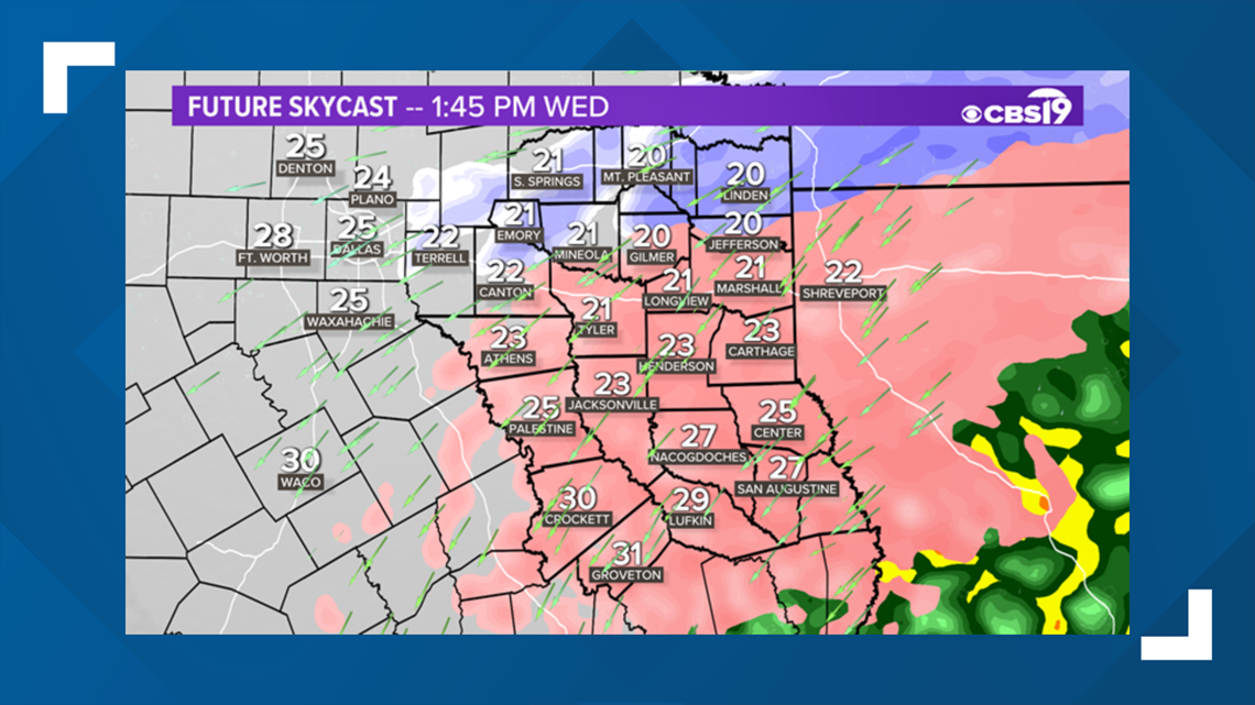
While Tyler will have a mix of freezing rain and sleet and snow, counties closer to the Red River will experience heavy snow, in the order of six to eight inches of snow.
This is a challenging forecast for central and East Texas and a bit concerning because most of the pieces of data we are looking at have between a quarter and three quarters of an inch of ice across a large portion of Deep East Texas.
If this amount of ice occurs then power outages and falling tree limbs will be likely.

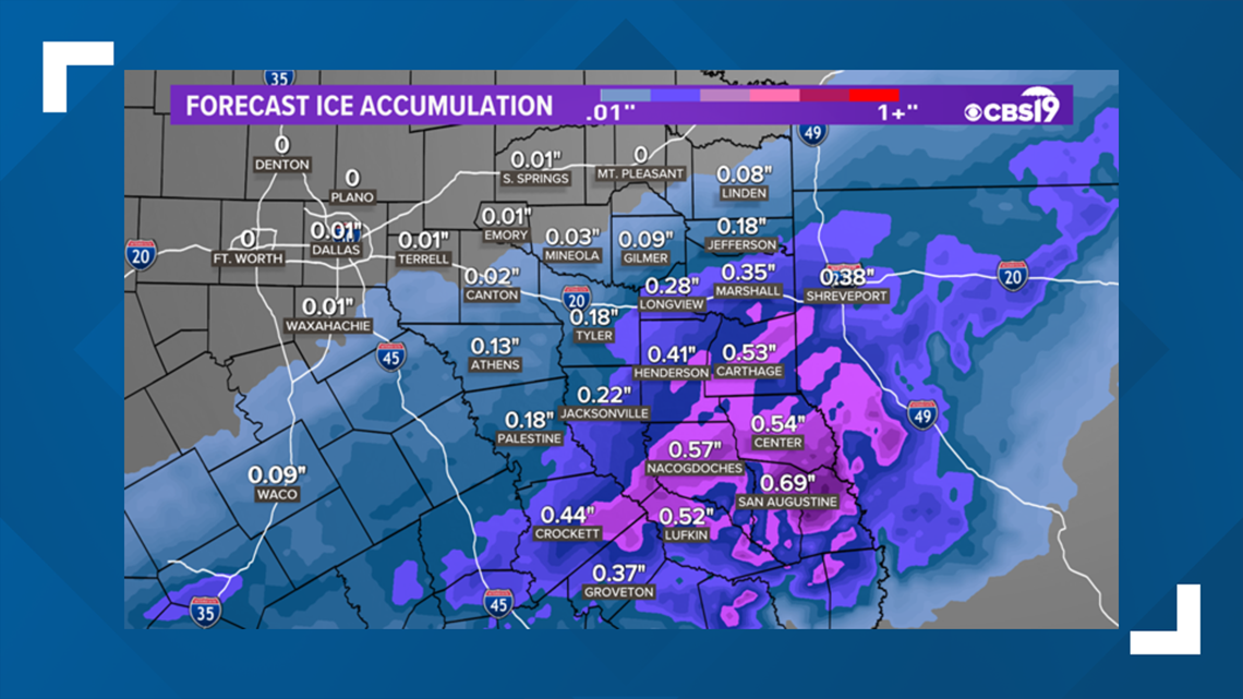
Remember sleet pings and freezing rain clings. This means sleet will bounce off what it hits and settle on the ground. Sleet causes more icy issues for roads and other surfaces. But freezing rain clings to trees, power lines, sidewalks, driveways and roads and if we get a half inch to three quarters of an inch of ice, there could widespread power outages and other damage.
We certainly don’t want freezing rain but it’s something to think about. Something to add to you action plan in the event we do have an ice storm.
We will keep you up to date on-air and on-line so keep checking back and please take the threat of an ice storm seriously.
We can always, scale down if it appears we will dodge the worst case scenario. It’s harder to recover if you are caught unprepared.